
Airport Data and Surface Safety: What Private Jet Pilots Need to Know
For private jet pilots, airport data goes far beyond runway length. Declared distances, pavement strength, taxiway layouts, hot spots and NOTAMs all help crews understand the operating environment, while new FAA surface safety technology adds another layer of situational awareness.
By Felipe Reisch · Sources: FAA runway safety guidance and the FAA Surface Safety Portfolio · Published 2 October 2026
The guide
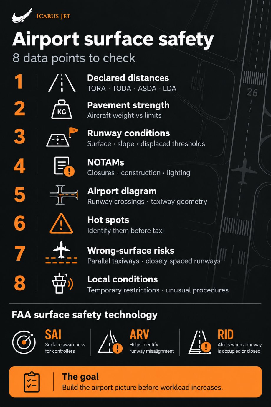
Runway length alone does not tell a crew whether an airport works. Declared distances, pavement strength, elevation and slope decide the performance case; the airport diagram, its hot spots and the current NOTAMs decide the taxi. Over 80 percent of pilot-caused runway incursions happen on the taxi out to the departure runway, so that taxi gets its own briefing. The FAA is adding three controller tools, SAI, ARV and RID, but they do not replace the crew’s own preparation.
The information available before a flight can reveal limitations that are not obvious from an airport’s basic specifications. It also helps crews anticipate where extra attention will be needed on arrival, during the taxi and on departure.
The FAA’s current focus on surface safety shows how closely airport data and safe ground operations are linked. The agency is deploying new technology to improve situational awareness and cut serious incidents on the airport surface.
For business aviation crews who regularly fly into unfamiliar airports, preparation means more than collecting information. It means knowing which airport data matters, and using it before the workload builds.
Building an accurate picture of the airport
When preparing for an unfamiliar airport, the first figure most pilots look at is the runway length. On its own it can mislead, because many other parameters decide whether an airport suits the operation.
The first step is to work out the distances actually available: TORA (takeoff run available), TODA (takeoff distance available), ASDA (accelerate-stop distance available) and LDA (landing distance available). Intersection departures, runway closures, temporarily displaced thresholds and construction all change how much pavement is really there for the aircraft. At Dallas Executive, for example, displaced thresholds leave 5,537 feet to land on runway 13 from 7,136 feet of pavement.
Airport elevation, runway slope, temperature, the headwind component and the estimated gross weight also feed the performance calculation, and together they decide whether the operation is feasible.
Pavement strength can decide it too. A runway may be long and wide enough for an aircraft while the pavement limits the weight at which that aircraft can operate.
This matters most when business jets operate away from major international airports. Regional and secondary airports are often closer to the final destination, but they may have been built with very different aircraft in mind. Deciding whether an airport is suitable takes a full assessment of the relevant data.
Airport data does not end at the runway
Once the performance numbers are done, the airport diagram is the next key piece of preflight information.
Taxiway layout, runway crossings, intersection geometry and holding positions all come into play during taxi and departure. Layouts range from simple single-runway fields to multiple parallel runways with complex, intersecting taxiways.
The FAA encourages pilots to review the airport diagram and its hot spots as part of preflight planning. It defines a hot spot as a location on an airport movement area with a history of potential risk of collision or runway incursion, where heightened attention by pilots and drivers is necessary.
For crews operating at an unfamiliar airport, that is valuable context. Knowing in advance where extra attention will be needed makes the taxi far simpler, and the airport diagram becomes part of preparing for surface operations. Our guide to runway incursions at KPDK shows how hot spots work at one busy US field.
Changes to airport infrastructure
Published information is the baseline, but conditions on the day can change the picture significantly. Taxiway closures for construction, partial runway closures, lighting outages, unserviceable signs, changed taxi routes and intersection departures that are no longer available all fall into this category.
This is where Notices to Air Missions (NOTAMs) become crucial. FAA runway safety guidance recommends checking current NOTAMs and the Automatic Terminal Information Service (ATIS) for runway and taxiway closures or construction, and keeping the airport diagram to hand while taxiing on the movement area.
For business aviation this matters even more, because destinations can change at short notice. Airline pilots fly into a relatively limited set of airports; business aviation crews may land at airports they have never seen before. Up-to-date information goes a long way towards closing that gap.
Data can also help prevent wrong-surface events
Beyond assessing an airport’s limitations, pilots can use airport information to anticipate what comes next. Before departure, crews know which runway crossings to look out for. Inbound, they can anticipate the runway exits and how the runway, the parallel taxiways and the terminal or parking area fit together.
That is straightforward while the aircraft is parked and the crew is studying the diagram. It becomes much harder while copying taxi instructions from ATC, with several tasks running in the cockpit at once.
According to the FAA, over 80 percent of pilot-caused runway incursions happen while taxiing to the departure runway. That is why the departure taxi deserves thorough preparation and a place in the taxi briefing: identifying the points that need extra attention in advance takes load off the crew in real time.
The FAA’s surface safety technology: SAI, ARV and RID
Alongside its runway safety programs, the FAA is rolling out a Surface Safety Portfolio that combines technology with operational measures. Part of the agency’s effort to reduce close calls on the airport surface, it improves surveillance and situational awareness for controllers. It has three parts.
- Surface Awareness Initiative (SAI). Gives controllers a visual display of ADS-B equipped aircraft and vehicles on the airport surface, filling the gaps where the tower cannot see parts of the airfield.
- Approach Runway Verification (ARV). Alerts controllers when an arriving aircraft is not lined up with the runway it was assigned, a sign of possible runway misalignment.
- Runway Incursion Device (RID). Warns controllers with visual and audio cues when a runway is occupied or closed. The FAA is installing it in 74 control towers, with the rollout due to finish by the end of 2026.
Local knowledge adds context to published information
Some of these systems serve controllers rather than pilots, but they show how surface safety is evolving: technology and situational awareness working from the same airport information. They add extra layers of protection. They do not take the responsibility for preparation off the crew.
Technology and airport data work best when crews arrive already knowing the environment that awaits them. That is why preparation matters so much during surface operations.
At Icarus Jet, airport research is part of international trip support. Confirming that an airport can accommodate the aircraft is only the beginning; crews also need an accurate picture of what they will meet on arrival and departure. Our airport guides start that picture for more than 80 airports.
Airport data is valuable because it lets pilots build that picture early. And once the aircraft starts moving, that preparation becomes part of surface safety.
Questions
Airport data and surface safety: questions the desk gets
What airport data should private jet pilots check before a flight?
Runway length and width, declared distances (TORA, TODA, ASDA and LDA), pavement strength, airport elevation, runway slope, obstacles and the aircraft’s performance figures. Then the airport diagram, its hot spots and taxiway layout, the current NOTAMs, and any construction or temporary closures.
Is runway length enough to decide whether an airport is suitable?
No. The published length ignores declared distances, displaced thresholds, closures, pavement strength, elevation, temperature, slope and the aircraft’s weight on the day. Any of them can shorten the runway the aircraft can actually use.
What are declared distances?
The distances an airport declares as available for takeoff and landing: TORA (takeoff run available), TODA (takeoff distance available), ASDA (accelerate-stop distance available) and LDA (landing distance available). Displaced thresholds, stopways and clearways mean they can differ from each other and from the runway’s physical length.
What is an airport hot spot?
The FAA defines a hot spot as a location on an airport movement area with a history of potential risk of collision or runway incursion, where heightened attention by pilots and drivers is necessary. Hot spots are marked on the airport diagram.
Why should pilots review the airport diagram before arrival?
It shows the runway exits, crossings and taxiway layout in advance, so the crew is not working them out while taxiing. That cuts the workload when the taxi instructions arrive.
When do most pilot-caused runway incursions happen?
According to the FAA, over 80 percent happen while taxiing to the departure runway. That is why the departure taxi deserves its own briefing, with the crossings and hot spots on the route identified before the aircraft moves.
What is a wrong-surface event?
A landing or takeoff on the wrong runway or on a taxiway, or a landing at the wrong airport. Closely spaced parallel runways, parallel taxiways and unfamiliar layouts are common contributing factors.
What is the FAA Surface Safety Portfolio?
Three FAA tools for controllers: the Surface Awareness Initiative (SAI), which shows ADS-B equipped aircraft and vehicles on the airport surface; Approach Runway Verification (ARV), which flags an arrival lined up with the wrong runway; and the Runway Incursion Device (RID), which warns when a runway is occupied or closed and is going into 74 control towers by the end of 2026.
Where this sits
The guides around this one
Flying into an unfamiliar airport? Briefed from the desk
Send the dates, the aircraft and the stops. You get the permits filed, the routing checked against the current picture, handling confirmed, and a number you can hold us to.
Contact Us