

Understanding EPU and Its Role in Modern Aircraft Navigation
Modern aircraft navigation is not simply about knowing where an aircraft is. Just as important is knowing how accurately the navigation system can determine that position, and whether the information stays reliable throughout the flight.
By Felipe Reisch · From the Icarus Jet trip support desk · Published 28 October 2026
The guide
EPU, Estimated Position Uncertainty, is the navigation system's own estimate of how far its calculated position can be trusted, built from GNSS, DME/DME, VOR/DME and inertial inputs. RNP sets the accuracy a route or approach demands, from 4 NM oceanic to 0.3 NM on an RNP approach final segment. SBAS (WAAS, EGNOS) adds corrections and integrity for LPV minima down to 200 ft; LNAV/VNAV can use SBAS or baro-VNAV; LNAV is lateral only to an MDA. If integrity is lost before the FAF, crews may drop to a higher line of minima; after it, a missed approach.
This is where Estimated Position Uncertainty (EPU) comes in. EPU is the navigation system’s estimate of the uncertainty in the aircraft position it has calculated. It tells the crew how far the displayed position can be trusted.
But how is EPU calculated? What role do GPS and the other satellite navigation systems play? And how do ABAS, GBAS and SBAS support the navigation performance that increasingly demanding instrument approaches require?
The answers help pilots understand what their navigation system can do, and where its limits are when conditions turn against them.
What is EPU and how is it calculated?
Estimated Position Uncertainty is the navigation system’s estimate of the uncertainty in its calculated aircraft position.
Depending on the aircraft and its avionics architecture, the Flight Management System (FMS) may combine information from several navigation sources:
- Global Navigation Satellite Systems (GNSS)
- Distance Measuring Equipment (DME/DME)
- VOR/DME navigation
- Inertial Reference Systems (IRS) or Inertial Navigation Systems (INS)
Each of these sources has its own positioning characteristics and its own uncertainties.
GPS positioning, for instance, relies on accurately measuring signal delays from satellites whose positions are known. The geometry of the satellites in view limits how accurate that position can be.
DME/DME positioning depends on where the ground stations sit relative to each other. IRS and INS calculate position from acceleration data and build up error over time.
The navigation system combines these inputs to estimate how uncertain its position is.
EPU is therefore not simply the difference between the aircraft’s actual and displayed positions. It is a calculated estimate of positioning uncertainty, based on the information available to the navigation system.
Anything that degrades positioning accuracy, such as poor satellite geometry, GNSS interference or the loss of non-satellite sources, can push the estimated uncertainty up.
The exact calculation, and how the uncertainty thresholds are interpreted, vary between aircraft systems.
Why EPU matters for RNAV and RNP operations
Area Navigation (RNAV) lets an aircraft follow a desired flight path using suitable navigation sensors, without having to fly directly between conventional ground-based navigation aids.
Required Navigation Performance (RNP) builds on RNAV by adding onboard performance monitoring and alerting.
Comparing the two gives useful context for EPU. EPU estimates navigation uncertainty, while RNP sets the performance criteria for a particular operation. Based on its avionics capabilities, the navigation system determines whether the required performance can be met.
Common navigation specifications include RNAV 2 or RNP 2 at 2 NM of lateral accuracy, RNAV 1 or RNP 1 at 1 NM, RNP 4 at 4 NM on oceanic and remote routes, and 0.3 NM on the final segment of an RNP approach (RNP APCH).
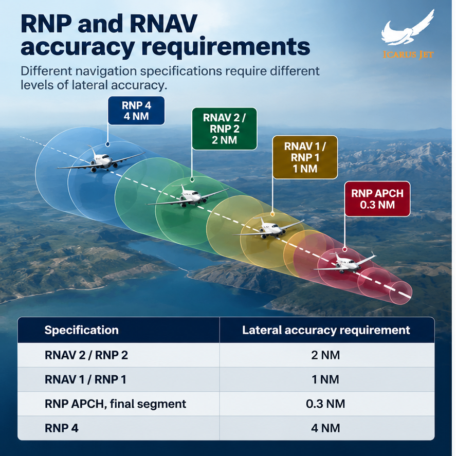
These values are lateral accuracy requirements for particular navigation specifications, not thresholds that apply to every phase of flight. RNP 4, for example, is used on oceanic tracks such as those covered in our North Atlantic contingency guide.
Pilots should also understand that EPU alone cannot definitively confirm whether RNP requirements are met. The avionics architecture affects that determination too.
As the aircraft moves toward an instrument approach, the required navigation performance usually becomes more demanding.
How GNSS and GPS contribute to EPU
Global Navigation Satellite System (GNSS) is the collective term for satellite navigation systems, including the United States’ GPS, Europe’s Galileo, Russia’s GLONASS and China’s BeiDou.
GPS satellites orbit about 12,550 miles (20,200 km) above Earth, transmitting signals that carry precise timing and position data.
The aircraft’s GNSS receiver uses the transmission times of those signals to work out its own location. Four satellites are enough to fix a three-dimensional position and correct the receiver’s clock error; additional satellites add redundancy and allow integrity monitoring.
The number of satellites is only part of the equation, though. Satellite geometry matters just as much: satellites spread across different parts of the sky generally give better positioning geometry than satellites clustered close together.
Atmospheric delays, signal reflections, satellite clock errors and interference can also affect positioning accuracy. Deliberate jamming is now a routine planning factor in some regions, as our Phenom 300 GPS jamming case shows.
If GNSS performance deteriorates for any reason, the navigation system may raise its estimated position uncertainty or lean more heavily on other sources. What it falls back on is covered in Felipe’s guide to how private jets navigate when GNSS fails.
GPS accuracy alone does not guarantee navigation performance in every aviation context. Estimating position uncertainty remains critical to judging whether the navigation system is performing as it should.
Understanding ABAS, GBAS and SBAS
Augmentation systems provide additional information to monitor, and in some cases correct, GNSS performance. There are three types.
Aircraft-Based Augmentation Systems (ABAS)
ABAS augments GNSS information using systems on board the aircraft.
Receiver Autonomous Integrity Monitoring (RAIM) checks redundant satellite measurements for anomalies that point to a navigation problem. Aircraft Autonomous Integrity Monitoring (AAIM) adds other aircraft information, including inertial data.
ABAS provides GNSS integrity monitoring, but not the wide-area differential corrections that SBAS offers.
Ground-Based Augmentation Systems (GBAS)
GBAS uses GNSS monitoring equipment installed at the airport to watch the satellite signals and calculate differential corrections.
The corrections and integrity information are sent by VHF datalink to aircraft equipped to receive them.
GBAS enables GLS approaches, with navigation service inside the approved coverage area, out to about 23 NM from the GBAS facility.
Satellite-Based Augmentation Systems (SBAS)
SBAS relies on an extensive network of ground monitoring stations that receive GNSS signals, check their integrity and broadcast corrections, via geostationary satellites, to SBAS-equipped aircraft.
Unlike GBAS, SBAS can serve very large geographic areas.
How WAAS and EGNOS support instrument approaches
Two prominent SBAS examples are the Wide Area Augmentation System (WAAS) in North America and the European Geostationary Navigation Overlay Service (EGNOS) in Europe. Both improve GPS navigation with correction and integrity information.
SBAS-capable receivers compute protection levels: bounds on the position error under defined integrity parameters.
The protection levels are compared against the alert limits set for the navigation task.
For pilots, the practical benefits are better navigation integrity, access to approved approaches with vertical guidance and, potentially, lower approach minimums without an ILS installed at the airport.
SBAS availability alone does not authorize an approach, however. Aircraft certification, receiver capability, operational approvals and published procedures all remain essential.
How EPU and satellite augmentation relate to approach minima
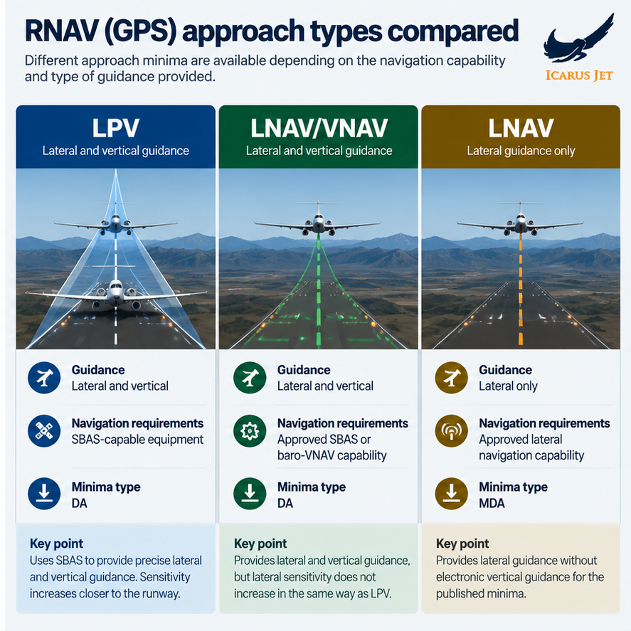
RNAV (GPS) procedures may publish different minima depending on the navigation capability available.
Understanding the differences between LPV, LNAV/VNAV and LNAV is essential when deciding which minima can be used.
LPV approaches
Localizer Performance with Vertical Guidance (LPV) uses SBAS to provide lateral and vertical guidance to a decision altitude (DA).
Its angular guidance becomes more sensitive as the aircraft gets closer to the runway, much like an ILS.
Some LPV procedures have decision altitudes as low as 200 feet above touchdown.
Despite this, LPV is classed as an approach with vertical guidance (APV), not an ICAO precision approach.
LNAV/VNAV approaches
LNAV/VNAV provides lateral and vertical guidance to a DA, using approved SBAS or barometric vertical navigation (baro-VNAV) capability.
Unlike LPV, its lateral guidance does not become angularly more sensitive closer to the runway.
Baro-VNAV operations may also be subject to temperature limits, because temperature affects barometric altitude.
LNAV approaches
LNAV provides lateral guidance only, without approved electronic vertical guidance for the published minima.
Pilots fly to a Minimum Descent Altitude (MDA) rather than the Decision Altitude (DA) used for LPV and LNAV/VNAV.
LNAV minima are generally higher, although the actual published values depend on the procedure and the obstacle environment.
What happens when navigation integrity is lost?
Before starting an instrument approach, pilots must confirm that the aircraft’s navigation capability and related systems are working, and that the capability the approach procedure requires is available.
If the system loses the integrity required for the approach, the avionics may show a Loss of Integrity (LOI) alert or another equipment-specific indication.
Before the Final Approach Fix (FAF), pilots may be able to switch to a different line of minima, for example from LPV to LNAV, if the remaining capability and their authorizations allow it.
After the FAF, a loss of the required navigation capability normally means a missed approach, unless the crew has the required visual references or another approved option.
Pilots should consider alternatives before beginning the approach, particularly in areas with known GNSS interference or published outages. Building those into the flight plan, and keeping them current through flight watch, is part of the trip support desk’s job.
Conclusion
The essential point is that a displayed aircraft position does not automatically mean the navigation system meets the accuracy and integrity requirements of the intended operation.
EPU gives insight into position uncertainty, while GNSS augmentation, performance monitoring and alerting determine whether the aircraft can safely fly the required procedure.
Understanding how these pieces work together lets pilots recognize degraded navigation performance and make informed decisions before it becomes a more serious problem.
Questions
EPU and approach minima: questions the desk gets
What does EPU stand for in aircraft navigation?
EPU stands for Estimated Position Uncertainty: the navigation system’s estimate of the uncertainty in the position it has calculated for the aircraft.
How is EPU calculated?
Depending on the avionics, the navigation computer processes information from GNSS, DME/DME, VOR/DME and inertial systems. It weighs the characteristics and estimated errors of the available sources to calculate how uncertain the position is.
What is the difference between RNP and EPU?
EPU is an estimate of how uncertain the aircraft’s position is. RNP is the accuracy, with monitoring and alerting, that a particular route or procedure requires. How the two are compared depends on the avionics architecture.
What are the differences between ABAS, GBAS and SBAS?
ABAS provides GNSS integrity monitoring on board the aircraft. GBAS uses ground stations at the airport to transmit corrections and integrity information, while SBAS provides wide-area corrections and integrity monitoring through a ground network and satellite broadcasts.
Does LPV need SBAS?
Yes. LPV relies on SBAS corrections and integrity monitoring for its lateral and vertical guidance. Standalone GPS without suitable augmentation cannot fly LPV minima.
Can pilots continue an RNAV approach if EPU increases?
An increase in EPU does not automatically mean the approach must be discontinued. It depends on whether the aircraft still meets the required navigation performance and integrity for that procedure.
Where this sits
The guides around this one
Routing through GNSS interference? Planned from the desk
Send the dates, the aircraft and the stops. You get the permits filed, the routing checked against the current picture, handling confirmed, and a number you can hold us to.
Contact Us