

How Private Jets Navigate When GNSS Fails: From INS and IRS to Modern Navigation Systems
Modern business jets depend heavily on satellite navigation, but what happens when GNSS becomes unavailable?
By Felipe Reisch · From the Icarus Jet trip support desk · Published 21 October 2026
The guide
When GNSS is lost, the flight management system falls back on DME/DME, then VOR/DME, then the inertial system. An IRS, standard on large-cabin and long-range jets, keeps calculating position on its own but drifts without updates; an AHRS, as on the Phenom 300, gives attitude and heading only. The question is whether the remaining source still meets the route's RNP, such as 10 NM for RNP 10 over the ocean. If it does not, the crew tells ATC and flies the contingency procedure; dispatch plans for this before departure.
Flight navigation has changed considerably over the past decades. Where it once relied on radio navigation beacons and mechanical instruments, modern aircraft have integrated navigation systems that combine several types of sensors and onboard equipment.
For today’s business aviation crews, the Global Navigation Satellite System (GNSS), which includes the US-operated Global Positioning System (GPS), is the primary means of establishing the aircraft’s position.
Because it is satellite based, the system provides navigation all over the world, including distant and oceanic airspace where ground infrastructure is missing.
GNSS is far from perfect, though. Its signal can be disturbed or jammed, by natural phenomena or by people, as our Phenom 300 GPS jamming case shows.
That raises a critical question for flight crews: what options does a business jet have to keep navigating when GNSS is unavailable?
The answer requires understanding the evolution of inertial navigation, the differences between INS, IRS and AHRS, and how pilots manage the navigation sources that remain.
The origins of inertial navigation
Before satellite navigation became widely available, long-distance flights presented a significant challenge. Aircraft crossing the Atlantic or Pacific could travel for hours beyond the coverage of ground-based navigation stations.
Early Boeing 747s and other airliners used the Inertial Navigation System (INS) to work out their own position independently.
INS is a mechanical system of gimbal-mounted gyroscopes and accelerometers that measure the aircraft’s movement. Once pilots entered the starting position and aligned the equipment, the INS calculated the change in the aircraft’s position from the measured accelerations.
It was a technological breakthrough: aircraft no longer needed constant information from external beacons.
But the system had one flaw. The accuracy of INS decreased during the flight, an effect known as inertial drift.
Pilots therefore had to understand the accuracy limits of their equipment and apply the position updates and cross-checks available to them.
From mechanical INS to modern IRS
Over time a new type of navigation system appeared: the Inertial Reference System (IRS).
Modern systems differ from mechanical INS installations in their design: most IRS equipment uses ring laser gyroscopes instead of moving gimbals.
A ring laser gyroscope measures the difference between laser beams travelling in opposite directions around a closed optical path. That removes many mechanical components while giving precise measurements of the aircraft’s attitude, heading and inertial movement.
After its initial alignment, an Inertial Reference System also calculates the aircraft’s geographical position independently of any outside signal.
Like mechanical INS, modern IRS equipment experiences inertial drift, although generally at a considerably lower rate.
Modern Flight Management Systems (FMS) can blend the data from the IRS and GNSS for a more precise position.
IRS is standard on most large-cabin and long-range business jets. The exact architecture varies between manufacturers and aircraft models.
Understanding AHRS in smaller business jets
Not every modern business jet carries a full inertial position reference system. The Phenom 300, for example, uses an Attitude and Heading Reference System (AHRS), which calculates the aircraft’s attitude and heading rather than its geographical position.
AHRS provides essential information about the aircraft’s orientation, including pitch, roll and heading. It uses electronic sensors to determine how the aircraft is positioned and moving around its axes.
An aircraft equipped with AHRS may keep displaying reliable attitude and heading information when satellite positioning is unavailable. The AHRS itself, however, cannot replace GNSS as an independent long-range position source.
The FAA draws this distinction in its Aeronautical Information Manual, which explains the different functions of INS, inertial reference units and AHRS.
How modern aircraft prioritize navigation sources
Modern FMS units can use several position sources at once, and onboard systems select some of them automatically.
The general order of sources can be described as follows:
- GNSS: the preferred position source for most modern aircraft.
- DME/DME: the aircraft calculates its position from distance measurements to two ground stations, where available.
- VOR/DME: a combination of the bearing from a VOR beacon and the distance from a DME station.
- IRS or legacy INS: an independent position estimate.
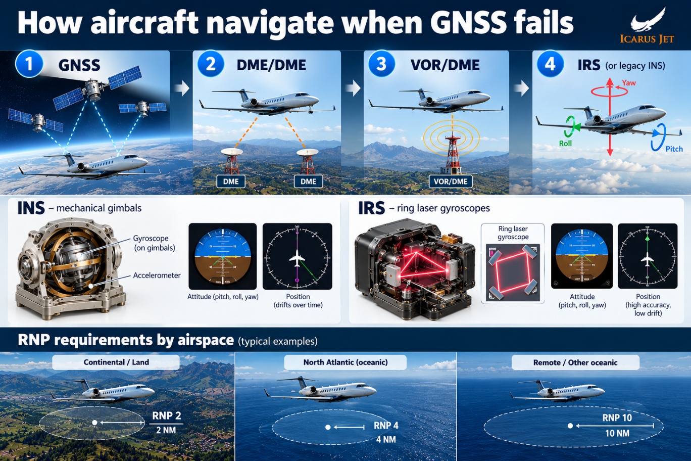
This is a simplified order rather than a universal sequence. Actual source selection depends on the aircraft’s flight management system, its installed equipment and the navigation infrastructure available.
In continental airspace, DME/DME and VOR/DME are usually good sources for the navigation system when GNSS is not available.
Over the ocean or in remote airspace, VOR beacons are almost impossible to use as a navigation source because there are so few stations.
In those circumstances, an aircraft equipped with an IRS keeps an important independent navigation capability.
How pilots know which navigation source they are using
One of the crucial aspects of modern navigation is knowing where the aircraft’s position is coming from.
Modern integrated avionics let pilots see information about each navigation sensor: GNSS, radio navigation, IRS and so on.
Depending on the aircraft, dedicated navigation pages can display sensor status, position information and navigation accuracy.
The key question for pilots is not simply whether the aircraft displays a position, but whether that position remains reliable.
If GNSS fails, the FMS may select one of the alternative sources.
Pilots must identify the selected navigation source, compare the position information available and verify whether the accuracy reported by the FMS meets the requirements of the airspace.
A change in navigation source does not necessarily mean the aircraft has lost its ability to navigate, but it may affect which routes and procedures remain available.
Conflicts between navigation sensors can indicate degraded position information, which happens when some sources provide inaccurate data.
Required Navigation Performance (RNP) expresses the navigation accuracy required for a particular operation, in nautical miles. RNP 2, for example, requires the aircraft to keep its total system error within 2 NM of its intended position for at least 95% of the flight time. RNP 4 and RNP 10 correspond to 4 NM and 10 NM.
Although commonly called RNP 10, that specification is designated RNAV 10 under ICAO’s performance-based navigation framework. The established RNP 10 terminology remains widely used in oceanic operations.
These values apply to specific routes and operations rather than to whole geographical regions. RNP 2 may be used for continental operations, while RNP 4 and RNP 10 apply to designated oceanic and remote routes. The North Atlantic also has more demanding navigation specifications in some airspace, covered in our North Atlantic contingency guide.
A working moving map does not automatically mean the aircraft still has the navigation performance required for its planned route or approach.
What happens when all external navigation sources fail?
Imagine a business jet flying over a remote area of ocean with GNSS unavailable.
Unlike in continental airspace, there are no VOR/DME stations nearby to give the pilots additional navigation data.
In an IRS-equipped aircraft, the inertial system can keep calculating the position independently, provided it remains serviceable and accurate enough for the intended operation.
If the aircraft is flying an RNP 10 route, for example, its remaining inertial navigation capability must meet the 10 NM accuracy standard. An aircraft approved to use IRS-only navigation for RNP 10 may continue within the applicable time and operational limits.
Losing GNSS does not automatically mean the aircraft keeps its RNP 10 capability, though. This is where the step from mechanical INS to modern IRS becomes particularly valuable.
An IRS may initially provide enough accuracy for an RNP 10 operation, but its position uncertainty grows without external updates. Crews must therefore consider how long the aircraft can keep meeting its approved navigation accuracy.
For aircraft without an independent inertial position capability, the crew must rely on the other navigation methods available and on approved contingency procedures.
These may include holding a known heading, using airspeed and wind information for dead reckoning, getting radar assistance once coverage is available, or coordinating an alternative route with air traffic control.
Radar vectors are another important resource, but they depend on surveillance coverage and working communications. They cannot be assumed over remote oceanic areas.
The role of pilots and dispatchers during navigation failures
Navigation planning begins before departure. Pilots and dispatchers must understand the aircraft’s installed equipment, the RNP requirements along the planned route, and whether the alternative navigation sources can maintain the required performance if GNSS becomes unavailable.
If the aircraft can no longer meet the navigation performance required for its route, the crew must advise air traffic control and follow the applicable contingency procedures. Depending on the circumstances, that may mean requesting a different routing, different separation, or a clearance into airspace with less demanding navigation requirements.
A dispatcher helps by assessing published information about GNSS disruption and the ground infrastructure available in remote airspace, and by changing the routing when needed. Flight watch keeps that picture current while the aircraft is airborne.
During the flight, the crew is responsible for following the approved procedures for operating the navigation system and for verifying its sources.
Loss of GNSS may also affect required navigation performance, approach availability and other aircraft systems that depend on satellite information. On long overwater legs it is part of the same planning picture as the diversion arcs in our ETOPS and time in jeopardy guide.
Ultimately, redundant navigation is only useful when pilots understand what each system can provide and, just as importantly, what it cannot.
Questions
Navigating without GNSS: questions the desk gets
What is the difference between INS and IRS?
An INS is a mechanical system that calculates position with gimbal-mounted gyroscopes, accelerometers and a navigation computer. A modern IRS provides inertial reference information, usually from ring laser gyroscopes, and is integrated with the aircraft’s flight management system. Both drift over time, the IRS at a much lower rate.
Does the Embraer Phenom 300 use AHRS or IRS?
The Phenom 300 uses an AHRS-based system, which provides attitude and heading references. An AHRS cannot calculate the aircraft’s position the way an IRS does, so it does not replace GNSS as a long-range position source.
Can aircraft navigate without GNSS?
Yes. Depending on the equipment fitted and where the aircraft is, it can use DME/DME, VOR/DME, inertial navigation and air traffic control assistance. Which routes and procedures remain available depends on whether the remaining sources meet the required navigation performance.
What happens if GNSS fails during an oceanic flight?
An IRS-equipped aircraft can keep calculating its position by inertial navigation, within its accuracy and time limits. For RNP 10 operations the aircraft must retain the required navigation performance and stay within its approved operational limitations; if it cannot, the crew advises ATC and follows the contingency procedures.
Why do inertial navigation systems experience drift?
An inertial system calculates position from measured acceleration and rotation. Small sensor errors build up over time, so the calculated position slowly drifts away from the true one until it is updated from an external source such as GNSS or DME.
Can air traffic control provide radar vectors if an aircraft loses navigation capability?
Yes, where suitable surveillance coverage and communications are available. Controllers may provide headings or other assistance, but radar vectors are not available everywhere, particularly over remote oceanic regions.
Where this sits
The guides around this one
Flying a long overwater leg? Planned from the desk
Send the dates, the aircraft and the stops. You get the permits filed, the routing checked against the current picture, handling confirmed, and a number you can hold us to.
Contact Us